Field Trips by Ellin Beltz |
Geological Field Trips -- Kankakee Area Copyright 2006 by Ellin Beltz | ||
|---|---|---|

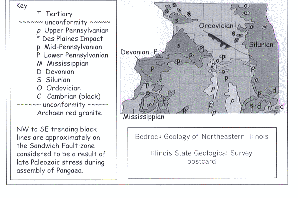
Illinois bedrock map |
Geological columns show the relationship of various rocks. Bedrock maps are what the rocks would look like at the surface, if all the loose surface material was removed. When you color in your bedrock map of Illinois, use a different color for each age of rock and color in the key and your geological column to match. Click on the small map of Illinois to go to a large version which has both "top of rocks" as well as a column key. A more detailed bedrock map of northern Illinois shows the region in greater detail. | 
Illinois stratigraphic column |
|
Click on the picture of the Illinois stratigraphic column to go to a larger version which has been annotated to correspond with localities mentioned in the following text.
Geological columns are only approximations of reality. Some attempt to show all the possible rocks in a given area; others try to show just the formations which remain. This diagram is of the latter type. No full geologic column is ever exposed to view. Parts may be filled in by studying rocks brought up during excavation or drilling. | ||
| It is possible to do all the things on this page in one day. | ||
La Salle Anticline - Field Trip Stops | ||
|---|---|---|
| Manteno | Kankakee State Park | References and Links |
Begin this trip at the Manteno I-57 exit. | ||
From Chicago take Interstate 90/94. Follow 94 southbound (Dan Ryan Expressway) to Interstate 57. Exit at Manteno. Head west over I-57 and turn left into the first street adjacent to
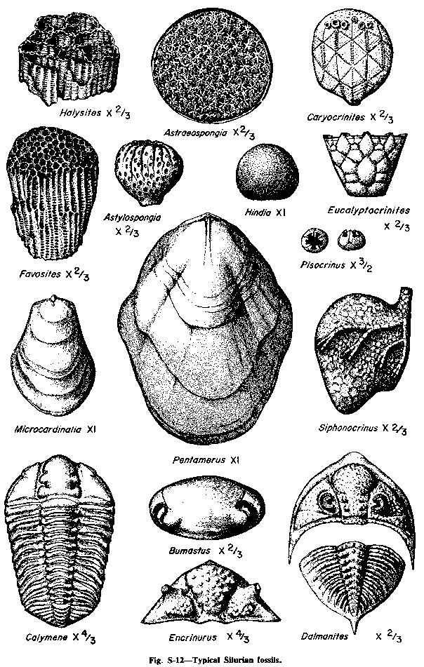
The retention pond next to the highway.If the pond is dry, walk down the slope and separate the rock layers to find fossils. The exposure is in Niagaran age (Silurian) dolomitic limestone. The trilobite casts are harder than the country rock and leave high quality molds. | 
Image courtesy of the USGS and Andy Partak | |

| Yolanda points out her first fossils with Gabe Lyon (left) while Ashley holds her first trilobite (right). |

|
|
"We found thirteen trilobites, several ammonoids, hundreds of other trace fossils and millions of worm burrows," wrote Ashley in her notes. Sisters for Science is part of Project Exploration, co-founded by Gabe Lyon and Paul Sereno.
We visited the retention pit at Manteno, Illinois on April 9, 2000. I was the only one who did not find a trilobite, but I found a 10-inch long ammonoid cast. Leaving the retention pond, drive west on the Manteno exit road ("9000N") about six miles west, through the town of Deselm which is marked by a tornado warning tower. Turn left (south) on 5000W, cross Rock Creek and continue south to Illinois 102. Turn right (northwest) onto 102 and immediately left (south) into | ||
Kankakee River State ParkMake a series of right turns to parallel the Kankakee River until you arrive at the parking lot at the pedestrian suspension bridge over Rock Creek. The rocks here are Niagaran age (Silurian) limestones and dolomitic limestones. | ||

| In summer, 1999 we visited the park with the Project Exploration Junior Paleontologists. This was the first time some of the JPs had been in water outside of a play park in their lives. |

|
|
Later, we discovered that invertebrates today live under rocks and in the water and had crayfish races.
On the way out, Kit found his first trilobite in the quarried cobbles used for bank armor near the suspension bridge (above right). The Park also has stacks, joints, one fault, a waterfall, perched water table, many stream features and the Neda Oolite contact with the overlying limestone. Fossils found here include both in-situ and loose ammonoids, reef building organisms and trilobites. | ||
|
On the Fall, 1999 Northeastern Illinois University Sedimentology #317 field trip, Kevin Goldman climbed the "Kankakee Arch," the only limestone arch in Northeastern Illinois big enough to admit a person.
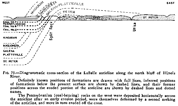
There is a structural feature also known as the "Kankakee Arch" which underlies the whole region. It was formed due to compressional stress at the end of the Paleozoic. |

| |

| The waterfall along Rock Creek has cut a canyon through Silurian Niagaran Limestones (Sugar Run and Joliet Formations). Start at the pedestrian suspension bridge and walk north. Cross the road bridge either on the surface, or by observing the limestone to which its piers are anchored. There is a large ammonoid on the rock to which the north end of the bridge is anchored. If you can find it, leave it for the next person. It would collapse if you tried to hammer it out anyway. Once you are north of the blacktop, measure to find all the features. | |
|
At about 225-235 feet you will be able to see a cave on the opposite side of the creek. At 455-465, looking down over the edge give a steep view down on a stack. At 1340-1365, you will be able to see the arch and the path to it. And at 3050-3060 feet, you will be able to see the waterfall. Two hundred feet further along, is a second path to the waterfall.
Retrace your steps to the parking lot by following the old airstrip. Keep an eye on the gravel here; some lovely fossils come from this local crushed rock. | ||
Reference material to prepare for the field trip. | ||
| ||
|
Information from the Illinois State Geological Survey.
| ||
Take another field trip...
In Illinois:
Montrose Beach .
Chicago River .
Kankakee River .
Dinosaur Lab Tour .
La Salle .
Lake Michigan Beaches .
Chicago's Michigan Avenue .
Southern Illinois .
Thornton Quarry
Beyond Chicago . Hawai'i . Humboldt County . Wyoming | |
Travel back in time...
William Alden's 1902 Chicago Folio |
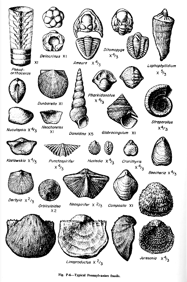
Learn Paleozoic fossils...
Read my First Families of Chicago |
Visit my Nifty Links...
Amphibians .
Archaeology .
Astronomy .
Australia .
Botany .
California .
Chemistry .
Chicago .
Dinosaurs .
Earthquakes .
Environmental Issues .
Ferndale .
Fossils .
Glaciers .
Humboldt County .
Illinois .
Kinetic Sculpture Races .
Lake Michigan .
Maps .
Math .
Minerals .
Moon .
National Parks .
Oceans .
Physics .
Plate Tectonics .
Rocks .
Rock Art .
Science Culture .
Volcanos .
Whole Earth
| |
|
Visit my home page ☯ Ellin Beltz - ebeltz@ebeltz.net
Updated: January 10, 2008 | |